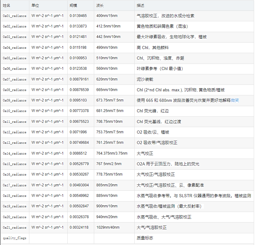
Google Earth Engine(GEE)——Sentinel-3 OLCI EFR:海洋和陆地彩色地球观测全分辨率数据集
海洋和陆地颜色仪器 (OLCI) 地球观测全分辨率 (EFR) 数据集包含 21 个光谱带的顶部大气辐射,中心波长范围在 0.4μm 和 1.02μm 之间,空间分辨率为 300m,每 2 天覆盖一次全球范围。OLCI 是 ESA/EUMETSAT Sentinel-3 任务中的仪器之一,用于测量海...
Google Earth Engine(GEE)——哥白尼大气监测 (CAMS) 全球气溶胶AOI近实时观测数据集
哥白尼大气监测服务 (CAMS) 全球近实时观测数据集哥白尼大气监测服务提供了在全球和区域范围内持续监测地球大气成分的能力。主要的全球近实时生产系统是一个数据同化和预测套件,每天为气溶胶和化学化合物提供两次为期 5 天的预测,这些都是化学方案的一部分。在 2021-07-01 之前,只有两个参数可用...

Google Earth Engine——陆地数据同化系统(LDAS)结合多种来源的观测数据(如降水表数据、卫星数据和雷达降水测量)
Land Data Assimilation System (LDAS) combines multiple sources of observations (such as precipitation gauge data, satellite data, and radar precipitat...

Google Earth Engine——臭氧总量绘图分光仪(TOMS)数据集代表了过去25年中可用于监测全球和区域臭氧总量趋势的主要长期、连续的卫星观测记录
The Total Ozone Mapping Spectrometer (TOMS) data represent the primary long-term, continuous record of satellite-based observations available for use ...
Google Earth Engine ——全球陆地数据同化系统(GLDAS)摄取了卫星和地面观测数据产品大气分析场、降水场和辐射场数据集
Global Land Data Assimilation System (GLDAS) ingests satellite and ground-based observational data products. Using advanced land surface modeling and ...

Google Earth Engine——热带国家500米处地面活木生物量密度的国家级数据集。这个数据集是由同地的实地测量、LiDAR观测和中分辨率成像光谱仪(MODIS)记录的图像组合而成。
A national-level map of above-ground live woody biomass density for tropical countries at 500m. This dataset was assembled from a combination of co-lo...

Google Earth Engine ——全球JRC/GSW1_2/MonthlyRecurrence数据集的观测数据
This dataset contains maps of the location and temporal distribution of surface water from 1984 to 2019 and provides statistics on the extent and chan...

Google Earth Engine ——全球JRC/GSW1_2/MonthlyHistory数据集的观测数据
This dataset contains maps of the location and temporal distribution of surface water from 1984 to 2019 and provides statistics on the extent and chan...
Google Earth Engine ——全球JRC/GSW1_2/Metadata数据集的观测数据
This dataset contains maps of the location and temporal distribution of surface water from 1984 to 2019 and provides statistics on the extent and chan...

Google Earth Engine ——全球JRC/GSW1_2/GlobalSurfaceWater数据集的观测数据
This dataset contains maps of the location and temporal distribution of surface water from 1984 to 2019 and provides statistics on the extent and chan...
本页面内关键词为智能算法引擎基于机器学习所生成,如有任何问题,可在页面下方点击"联系我们"与我们沟通。

google engine相关内容
- google earth engine栅格
- google earth engine
- google earth engine下载
- google engine数据
- google engine模型
- google engine生物量
- google earth engine遥感
- google engine地上
- google engine构建
- google engine导出
- google engine空间
- google earth engine gee landsat
- google earth engine evi
- google earth engine gee contain
- google engine gee
- google engine森林
- google earth engine数据集
- google earth engine森林
- google engine近地表
- google engine gee数据集
- google earth engine图像
- google engine道路
- google engine项目
- google earth engine卫星雷达
- google earth engine modis图像
- google earth engine图像数据集
- google engine modis
- google earth engine gee热带森林
- google earth engine gee空间
- google engine湿润
- google engine河流
- google earth engine oeel
- google engine影像
- google earth engine链接
- google earth engine代码
- google engine数据代码
- google earth engine gee加载图表
- google earth engine图表
- google engine gee加载
- google earth engine加载图表
- google engine分辨率
- google earth engine影像分辨率
- google earth engine像素
- google engine gee像素
- google earth engine像素分辨率
- google engine firms火灾
- google earth engine gee矢量数据
- google engine矢量数据
- google engine产品数据
google更多engine相关
- google earth engine数据数据集
- google engine植被
- google earth engine global
- google engine数据集数据
- google engine dem
- google earth engine人口
- google earth engine面积
- google engine归一化数据集
- google earth engine影像
- google engine copernicus数据集
- google earth engine归一化指数
- google engine terra
- google earth engine系统
- google engine温度数据集
- google engine gee ndvi
- google engine landsat8
- google earth engine gee下载
- google earth engine aqua
- google engine landsat归一化
- google earth engine归一化指数数据集
- google earth engine网格
- google earth engine测量
- google engine反射率
- google earth engine landsat影像
- google engine landsat归一化数据集
- google engine modis产品
- google earth engine s5p数据集
- google engine土壤厘米平均值
- google engine noaa
- google engine cdr
- google earth engine面积数据集
- google earth engine观测数据
- google engine landsat植被
- google earth engine landsat归一化指数
- google earth engine地表数据集
- google earth engine global 500m
- google earth engine产品modis
- google earth engine校正
- google engine error
- google earth engine gee分辨率
- google earth engine数据集modis
- google earth engine jrc数据集
- google engine landsat归一化指数
- google engine ndwi
- google earth engine谷歌地球引擎数据
- google earth engine函数
- google engine wwf数据集排水
- google earth engine landsat归一化数据集
- google engine gee栅格
- google engine wwf分辨率
google您可能感兴趣
- google镜像仓库
- google地址
- google machine
- google system
- google map
- google真机
- google大语言模型
- google gemma
- google指令
- google python
- google earth
- google数据集
- google gee
- google数据
- google play
- google分辨率
- google chrome
- google开源
- google应用
- google影像
- google解析
- google浏览器
- google分析
- google搜索
- google谷歌
- google网站
- google地图
- google landsat
- google ai